


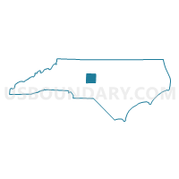
Randolph County PUMA, North Carolina
About
Outline

Summary
| Unique Area Identifier | 193609 |
| Name | Randolph County PUMA |
| State | North Carolina |
| Area (square miles) | 789.35 |
| Land Area (square miles) | 782.52 |
| Water Area (square miles) | 6.83 |
| % of Land Area | 99.13 |
| % of Water Area | 0.87 |
| Latitude of the Internal Point | 35.70991480 |
| Longtitude of the Internal Point | -79.80621530 |
Maps

Graphs
Select a template below for downloading or customizing gragh for Randolph County PUMA, North Carolina


Neighbors
Neighoring Public Use Microdata Area (by Name) Neighboring Public Use Microdata Area on the Map
- Alamance County--Burlington City PUMA, NC
- Chatham & Lee Counties PUMA, NC
- Davidson County PUMA, NC
- Guilford County (South)--High Point City PUMA, NC
- Moore & Montgomery Counties PUMA, NC
Top 10 Neighboring County (by Population) Neighboring County on the Map
- Guilford County, NC (488,406)
- Davidson County, NC (162,878)
- Alamance County, NC (151,131)
- Randolph County, NC (141,752)
- Moore County, NC (88,247)
- Chatham County, NC (63,505)
- Montgomery County, NC (27,798)
Top 10 Neighboring County Subdivision (by Population) Neighboring County Subdivision on the Map
- High Point township, Guilford County, NC (79,032)
- Thomasville township, Davidson County, NC (39,010)
- Trinity township, Randolph County, NC (26,604)
- Asheboro township, Randolph County, NC (23,561)
- Matthews township, Chatham County, NC (13,442)
- Jamestown township, Guilford County, NC (12,643)
- Fentress township, Guilford County, NC (10,372)
- Franklinville township, Randolph County, NC (10,080)
- Randleman township, Randolph County, NC (9,536)
- Conrad Hill township, Davidson County, NC (9,401)
Top 10 Neighboring Place (by Population) Neighboring Place on the Map
- High Point city, NC (104,371)
- Thomasville city, NC (26,757)
- Asheboro city, NC (25,012)
- Archdale city, NC (11,415)
- Trinity city, NC (6,614)
- Randleman city, NC (4,113)
- Liberty town, NC (2,656)
- Ramseur town, NC (1,692)
- Franklinville town, NC (1,164)
- Staley town, NC (393)
Top 10 Neighboring Unified School District (by Population) Neighboring Unified School District on the Map
- Guilford County Schools, NC (488,406)
- Alamance-Burlington Schools, NC (151,131)
- Davidson County Schools, NC (127,662)
- Randolph County Schools, NC (113,222)
- Moore County Schools, NC (88,247)
- Chatham County Schools, NC (63,505)
- Asheboro City Schools, NC (28,530)
- Montgomery County Schools, NC (27,798)
Top 10 Neighboring State Legislative District Lower Chamber (by Population) Neighboring State Legislative District Lower Chamber on the Map
- State House District 61, NC (87,087)
- State House District 54, NC (83,728)
- State House District 52, NC (83,301)
- State House District 58, NC (83,145)
- State House District 64, NC (80,704)
- State House District 80, NC (78,723)
- State House District 67, NC (75,179)
- State House District 70, NC (72,392)
- State House District 66, NC (70,881)
- State House District 60, NC (70,339)
Top 10 Neighboring State Legislative District Upper Chamber (by Population) Neighboring State Legislative District Upper Chamber on the Map
- State Senate District 18, NC (207,334)
- State Senate District 22, NC (202,925)
- State Senate District 26, NC (196,857)
- State Senate District 33, NC (189,009)
- State Senate District 28, NC (177,037)
- State Senate District 24, NC (174,850)
- State Senate District 29, NC (169,550)
Top 10 Neighboring 111th Congressional District (by Population) Neighboring 111th Congressional District on the Map
- Congressional District 2, NC (741,576)
- Congressional District 12, NC (736,346)
- Congressional District 6, NC (714,412)
- Congressional District 8, NC (709,449)
Top 10 Neighboring Census Tract (by Population) Neighboring Census Tract on the Map
- Census Tract 314, Randolph County, NC (8,452)
- Census Tract 202, Chatham County, NC (7,666)
- Census Tract 9602, Montgomery County, NC (7,370)
- Census Tract 310, Randolph County, NC (7,151)
- Census Tract 308.01, Randolph County, NC (7,148)
- Census Tract 9502, Moore County, NC (7,118)
- Census Tract 313.06, Randolph County, NC (6,845)
- Census Tract 611, Davidson County, NC (6,744)
- Census Tract 303.01, Randolph County, NC (6,501)
- Census Tract 9601, Montgomery County, NC (6,431)
Top 10 Neighboring 5-Digit ZIP Code Tabulation Area (by Population) Neighboring 5-Digit ZIP Code Tabulation Area on the Map
- 27360, NC (46,084)
- 27292, NC (39,787)
- 27205, NC (33,216)
- 27260, NC (24,023)
- 27262, NC (23,934)
- 27263, NC (21,414)
- 27203, NC (21,108)
- 27344, NC (18,022)
- 27317, NC (16,959)
- 27370, NC (15,052)